
Early Printed Map Collection
Alternative Title
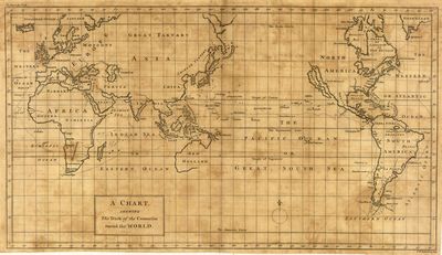
Chart showing the track of the Centurion round the world
Files
Download
Download Full Text (3.5 MB)
Preview
Publisher
Printed for W. Strahan ( London )
Creation Date
1780
Scale
Scale not given.
Coordinates
70 x -180, -70 x -180, -70 x 180, 70 x 180 ( Map Coverage )
Physical Collection
Early Printed Map collection (Rare Maps)
Holding Location
University of South Florida
Language
English
Media Type
cartographic
Format
Map
Identifier
U16-0107
Recommended Citation
Seale, Richard William, "A chart shewing the track of the Centurion round the world" (1780). Early Printed Map Collection. Image 20.
https://digitalcommons.usf.edu/fl_maps_early/20
Rights Statement

