

Florida Maps Collection
Files
Download Full Text (1.4 MB)
Preview
Publisher
Printed and sold by Tho. Bowles, John Bowles, and by I. King
Time Period
173-?
Abstract
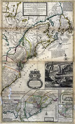
containing Newfoundland, New Scotland, New England, New York, New Jersey, Pensilvania, Maryland, Virginia, and Carolina according to the newest and most exact observations
Keywords
Atlantic Coast (North America), North America, Great Britain, America, North America, East (U.S.), Colonial cities, Indians of North America, Colonies
Subject: geographic
Atlantic Coast (North America), North America, Great Britain, America, North America, East (U.S.)
Holding Location
University of South Florida Library
Language
English
Format
Map
Identifier
U15-0058
Recommended Citation
Moll, Herman, "A new and exact map of the dominions of the King of Great Britain on ye continent of North America" (2021). Florida Maps Collection. Image 77.
https://digitalcommons.usf.edu/fl_maps_collection/77
Keywords
Atlantic Coast (North America), North America, Great Britain, America, North America, East (U.S.), Colonial cities, Indians of North America, Colonies
Rights Statement

