

Florida Maps Collection
Alternative Title
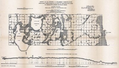
Eastern section, from Lake Winder to Tohopokeliga Lake
Files
Download
Download Full Text (745 KB)
Preview
Publisher
U.S. Engineer Office
Creation Date
1882
Time Period
1882
Keywords
Florida, Canals
Subject: geographic
Florida
Holding Location
University of South Florida Library
Language
English
Format
Map
Identifier
U15-0094
Recommended Citation
Williamson, W. G., "Survey for the opening of steamboat communication from Saint John's River, Fla., by way of Tohopokeliga Lake, to Charlotte Harbor or Peace Creek" (1882). Florida Maps Collection. Image 46.
https://digitalcommons.usf.edu/fl_maps_collection/46
Keywords
Florida, Canals
Rights Statement

