

Florida Maps Collection
Files
Download Full Text (78.1 MB)
Preview
Publisher
Matthews-Northrup Co.
Time Period
1894?
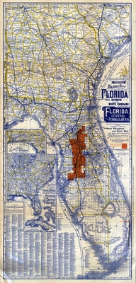
Abstract
showing complete system of Florida Central and Peninsular R.R
Keywords
South Carolina, Florida, Florida, Georgia, South Carolina, Florida, Georgia, Railroads, Railroads, Railroads, Real property
Subject: geographic
South Carolina, Florida, Florida, Georgia, South Carolina, Florida, Georgia
Holding Location
University of South Florida Library
Language
English
Format
Map
Identifier
U15-0121
Recommended Citation
Matthews-Northrup Company and Florida Central and Peninsular Railroad Company, "Geographically correct indexed township map of Florida, middle and southern Georgia, and southern South Carolina" (2021). Florida Maps Collection. Image 112.
https://digitalcommons.usf.edu/fl_maps_collection/112
Keywords
South Carolina, Florida, Florida, Georgia, South Carolina, Florida, Georgia, Railroads, Railroads, Railroads, Real property
Rights Statement

